Gorringe seamount
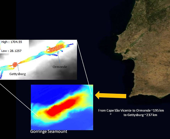
The Gorringe seamount is located in the Portuguese exclusive economic zone (EEZ) and it has been visited several times by various scientific expeditions. It as been recommended by the World Wild Fund to be included in the OSPAR network of marine protected areas (http://www.ngo.grida.no/wwfneap/Projects/MPAmap.htm). Several water masses from different origins are present in the study area. Gorringe is an important constraint for Mediterranean Water trajectory and a site of meddy formation. There are some taxonomic data from the Gorringe, at least, since 1967 (http://seamounts.sdsc.edu). It has a NE-SW orientation, with 250 km length and 80 km width. The shallower depths (between 24 and 54 m) correspond to the Gettysburgh and the Ormonde peaks.
A seamounts is any topographically distinct seafloor feature with, at least, a 100 m height, without breaking the sea surface [1].
These are oases of food, with high biological diversity and large abundance of fish and invertebrates [2], surrounded by deep oceanic waters.
Seamount research started over 100 years ago [3]. Since then, several key questions about seamounts ecology were put forward, some of which are still to be answered, such as:
“what physico-chemical or biotic factors drive the apparent high abundance of life over seamounts?”.
[1] Pitcher, T.J., Morato, T., Hart, P.J.B., Clark, M.R., Haggan, N., Santos, R.S., (eds.)(2007). Seamounts: Ecology, Fisheries & Conservation. Blackwell Publishing.
[2] Pitcher, T.J., Bulman, C. (2007). Raiding the larder: a quantitative evaluation framework and trophic signature for seamount food webs. In: (Pitcher et al., eds.) Seamounts: Seamounts: Ecology, Fisheries & Conservation, pp. 282 – 295. Blackwell Publishing.
[3] Brewin, P.E., Stocks, K.I., Menezes, G. (2007). A history of seamount research. In:(Pitcher et al., eds.) Seamounts: Seamounts: Ecology, Fisheries & Conservation, pp. 41– 61. Blackwell Publishing.